
Serving West Texas & New Mexico


INSURANCE SOLUTIONS
CLEARER EVIDENCE.
BETTER DECISIONS.
Professional aerial imaging and documentation to support insurance claims throughout Texas & New Mexico.
TX. RED DIRT DRONE SERVICE provides accurate, detailed aerial documentation to help insurance professionals evaluate damage, verify loss conditions, and make informed decisions quickly and confidently.

FASTER CLAIMS PROCESS

REDUCE RISK

DETAILED VISUAL DATA

PROFESSIONAL SERVICE
INSURANCE SOLUTIONS
Our drone service provide valuable data and visual documentation to support property, liability, and casualty, we deliver accurate information that helps you move claims forward.
AERIAL INSIGHTS FOR A WIDE RANGE OF CLAIMS

Property Damage Assessment

Roof Inspections

Commercial Properties

Agricultural Claims

Industrial & Oilfield Sites

Construction Losses

Auto & Liability Claims

Castastrophe Response
REAL DATA. REAL RESULTS.
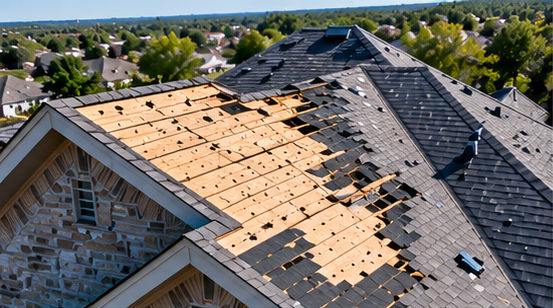
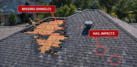
High-resolution aerial imagery provides the clarity needed to evaluate claims, document site conditions, and create a reliable visual record.

Roof Damage Documentation

Fire Damage Documentation

Flood Damage Overview

Agricultural Claim Documentation
WHY USE DRONE IMAGERY?
Provides a comprehensive view of the loss area
Captures difficult-to-access locations efficiently
Provides accurate, time-stamped visual documentation
Helps document the extent of visible damage
Reduces the need for repeated site access
Creates a visual record for claim review
Supports before-and-after comparisons
Provides organized imagery for adjusters, investigators, attorneys, and property owners

INSURANCE SUPPORT
GET THE DATA YOU NEED
Professional aerial documentation for insurance claims throughout Texas & New Mexico.
WHAT YOU RECEIVE
Depending on the project, deliverables may include:
High-resolution aerial photographs
4K aerial video
Roof and property overview imagery
Detailed images of visible areas of concern
Before-and-after comparisons
GPS-referenced locations when applicable
Orthomosaic maps when requested
Thermal imagery when requested
Organized digital image files
Written documentation summaries when requested

INSURANCE & PROPERTY DOCUMENTATION