
Serving West Texas & New Mexico


CONSTRUCTION DOCUMENTATION
SEE THE BIGGER PICTURE.
BUILD WITH CONFIDENCE.
TX. RED DIRT DRONE SERVICE provides professional aerial documentation, mapping, and site data for construction projects throughout West Texas & New Mexico.
From initial site conditions through project completion, drone technology gives contractors, owners, developers, and project managers a clear visual record of progress and changing site conditions.

IMPROVE SAFETY

SAVE TIME

MAKE BETTER DECISIONS

PROFESSIONAL SERVICE
CONSTRUCTION DRONE SERVICES
AERIAL DATA FOR EVERY PHASE

Construction Progress Documentation
Earthwork & Cut/Fill
Documentation


Orthomosaic Site Mapping
Before & After Documentation
Our drone service provide valuable data and visual documentation to support planning, construction, and project closeout.


Site & Infrastructure Documentation
3D Site Modeling

Stockpile & Volumetric
Measurements
Recurring Project Monitoring


CONSTRUCTION FIELD PRICING
Starting at $450
Includes up to 2 hours on site at one construction project location.
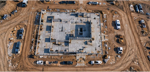
Basic service includes professional aerial documentation of the construction site, providing clear visual records of project progress, site conditions, structures, equipment, and ongoing work.
INCLUDED:
Pre-flight and site planning
Up to 2 hours of on-site operations
Aerial overview of the construction site
High-resolution aerial photographs
4K aerial video when requested
Documentation of project progress and visible site conditions
Documentation of structures, equipment, materials, and work areas
Organized digital image and video files
Digital delivery
Additional on-site time: $175/hour
READY TO DOCUMENT YOUR NEXT PROJECT?
WHAT YOU RECEIVE
Depending on the project and services selected, deliverables may include:
High-resolution aerial photographs
4K aerial video, upon request